1. Honolulu, Hawaii
Honolulu might look like paradise, but the H-1 freeway turns into a crawling line of brake lights almost daily. The city grew quickly without expanding its main arteries in time, leaving drivers inching along even outside rush hour. Add in the fact that mountains limit where new roads can be built, and you’ve got a natural bottleneck. Locals often joke that the only thing slower than vacation traffic is the commute.
What makes Honolulu a real traffic trap is how so many neighborhoods funnel onto just a few major routes. There aren’t many alternate east–west corridors, so one accident can freeze the whole system. Tourism adds a steady stream of rental cars that never really disappears. Even routine errands can feel like a strategic mission.
2. Los Angeles, California

LA didn’t set out to become the nation’s traffic poster child, but decades of car-first planning sealed its fate. The city kept expanding outward, adding suburbs faster than it added viable transit. Freeways like the 405 and 101 can feel like parking lots at nearly any hour. Drivers often plan their lives around avoiding peak congestion.
Its accidental trap comes from the sheer number of cars tied to limited chokepoints in canyons and passes. Even widening roads hasn’t solved the issue, since more lanes just attracted more vehicles. The region’s jobs are spread out, forcing long cross-county commutes. As a result, residents spend an astonishing amount of time stuck behind bumpers.
3. Boulder, Colorado
Boulder didn’t intend to engineer gridlock, but strict growth boundaries boxed roads into a tight footprint. The city preserved open space so effectively that there’s little room to add new corridors. As population climbed, the existing routes became overloaded. Commuters from nearby towns feed right into these limited access points.
With highways like US-36 funneling traffic toward downtown, even small delays ripple through the network. Cycling culture is strong, but it hasn’t offset the influx of regional commuters. The contrast between scenic vistas and jammed roads is striking. Many residents love the protected environment but curse the bottlenecks.
4. Austin, Texas
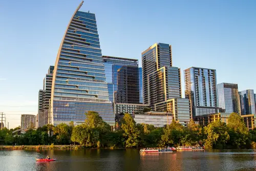
Austin’s boom blindsided its road network, which wasn’t designed for such explosive growth. The city relied heavily on I-35, one of the busiest interstates in the country, and never built enough parallel alternatives. As tech companies arrived, so did tens of thousands of new drivers. Now the interstate often clogs for miles.
The trap stems from development happening faster than infrastructure plans could keep up. Neighborhoods expanded outward while the core remained tied to just a few major highways. Construction projects aimed at fixing congestion often make things worse before they improve. It leaves drivers navigating a constant maze of detours and delays.
5. Nashville, Tennessee
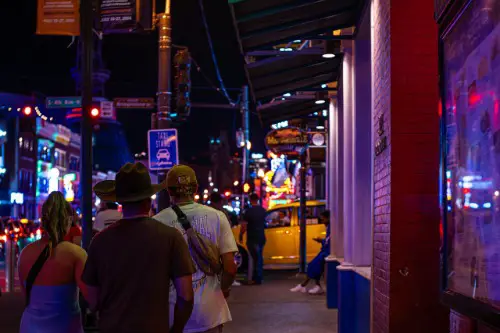
Nashville’s popularity soared, but its roads stayed mostly the same size. The city’s ring of interstates—especially the I-24 corridor—became notorious for heavy congestion. Downtown events add unpredictable surges of traffic that overwhelm narrow feeder streets. Even locals struggle to time their commutes wisely.
The unintentional trap comes from rapid population growth concentrated in areas without adequate transit. Suburbs expanded outward with few alternate routes into the city center. Tourists heading to entertainment districts create another layer of gridlock. It’s the classic case of a city outgrowing roads that once worked just fine.
6. Seattle, Washington
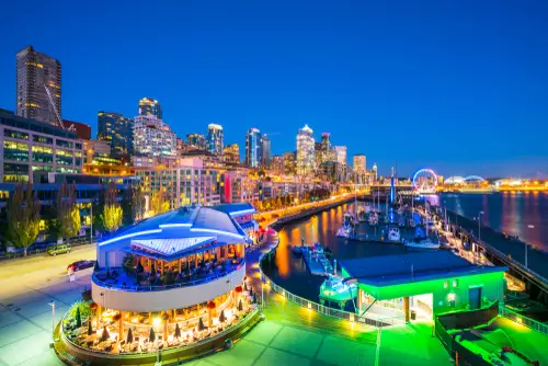
Seattle’s natural beauty hides a maze of water crossings that create unavoidable chokepoints. Bridges like the I-5 Ship Canal and SR-520 funnel huge volumes of cars through just a few lanes. The city’s hills and lakes limit where new roads can even be placed. That geography alone makes congestion a near certainty.
Its traffic trap formed because growth never slowed, even as space for expansion ran out. Longer commutes from sprawling suburbs compound the issue. When a bridge closes or a lane narrows, the entire region feels it. Residents often develop backup plans for their backup plans.
7. San Francisco, California
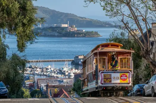
San Francisco’s narrow peninsula shape leaves very little room for road expansion. With water on three sides, nearly all traffic funnels through a handful of bridges and highways. The Bay Bridge is especially infamous for its jams. Even local streets can gridlock due to steep hills intersecting tight intersections.
The city never intended to become so car-heavy, but regional commuting patterns trapped it. Workers coming in from the East Bay and South Bay swell traffic beyond what the infrastructure was built for. Transit helps, but congestion still spills over onto major approaches. It’s a postcard city with decidedly un-postcard traffic.
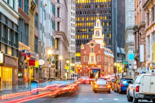
8. New York City, New York
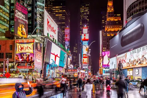
New York’s traffic woes stem from a century of dense development and limited Manhattan crossings. Bridges and tunnels like the Lincoln and Holland carry far more vehicles than they were meant to. Congestion pricing debates show just how serious the issue has become. Even taxis and rideshares contribute to endless gridlock.
The trap is partly rooted in geography and partly in historic planning. Manhattan streets were laid out long before modern traffic volumes existed. Add millions of daily commuters, and you get predictable chaos. The city’s pace may be fast, but its cars certainly aren’t.
9. Miami, Florida
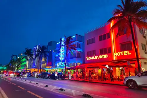
Miami’s development burst outward in every direction without enough major east–west connectors. I-95 and the Dolphin and Palmetto expressways bear more traffic than they can comfortably handle. Beach access roads get jammed during tourist seasons. Even short drives can stretch into odysseys.
Its trap formed when car dependency grew faster than public transit options. Neighborhoods expanded into former swamp areas without wide corridor planning. Seasonal visitors push the system beyond breaking point. The sun stays bright, but patience often runs thin.
10. Atlanta, Georgia
Atlanta accidentally created one of the country’s densest highway interchanges. The “Spaghetti Junction” and the downtown connector merge multiple interstates into tight bundles. These were bold engineering feats, but they didn’t anticipate modern volumes of suburban commuters. Now even minor fender benders cause massive backups.
The trap really comes from sprawling development radiating far beyond the city core. Drivers funnel into a few overburdened routes every morning and evening. Transit coverage hasn’t kept pace with the outward growth. As a result, cars dominate the landscape and the delays that come with them.
11. Chicago, Illinois
Chicago’s traffic revolves around a few major expressways that converge downtown. The Kennedy Expressway, in particular, is infamous for long travel times. The city’s grid system helps, but it can’t overcome demand on these central routes. Winter weather often makes everything even slower.
Its trap stems from decades of commuters driving in from widespread suburbs. Public transit exists, but many job centers sit beyond convenient rail access. The expressways simply can’t absorb the volume they’re expected to carry. It leaves Chicagoans resigned to slow crawls at nearly every rush hour.
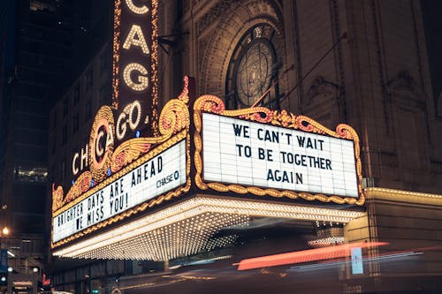
12. Boston, Massachusetts
Boston’s road network is a tangle of colonial-era streets that were never designed for modern cars. Many routes twist unpredictably, creating natural choke points. Even the Big Dig couldn’t fully untangle the city’s complexity. Drivers often find themselves circling just to get onto the right street.
The trap formed as modern development layered over historic road layouts. Commuters from surrounding towns pour into routes that bottleneck near the city center. Limited direct connections between neighborhoods worsen the load on main corridors. The charm of old streets comes with the curse of constant congestion.
13. New Orleans, Louisiana
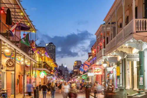
New Orleans built its roads on a patchwork of swamps, levees, and winding waterways. That geography leaves limited room for expanding major corridors like I-10. Special events and tourism amplify congestion around the French Quarter and downtown. Even normal weekends can feel jammed.
Its trap arose because the city expanded in oddly shaped pockets constrained by water. Traffic gets funneled into a handful of bridges and causeways. The Lake Pontchartrain Causeway creates its own rushes at peak times. Between geography and growth, the city often chokes on its own charm.
14. Denver, Colorado
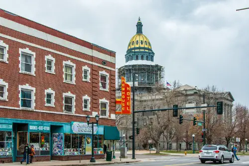
Denver grew rapidly along a single major artery: I-25. As new suburbs popped up along the corridor, the interstate reached capacity far sooner than expected. Frequent construction projects only add to travel times. Drivers often feel trapped between downtown congestion and suburban bottlenecks.
The problem stems from limited alternate north–south routes. Much of the region’s commuting depends on this single spine. When weather strikes, reliability plummets even further. Denver’s growth outpaced its freeway planning by a long shot.
15. Portland, Oregon
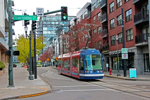
Portland prides itself on smart urban planning, but it didn’t foresee just how fast the region would grow. I-5 and I-205 carry heavy demand, especially near the Columbia River crossings. The bottleneck at the Interstate Bridge has become a long-running headache. Even locals who bike or take transit still notice the gridlock.
The trap came from restricting sprawl to preserve green space, leaving limited room for new highways. As more people poured in, the existing corridors hit their limits. Cross-river commuters from Washington add thousands more vehicles daily. The city’s livability remains high, but its traffic definitely does not.
This post 15 Towns That Accidentally Built Themselves Into Traffic Traps was first published on American Charm.