1. Overseas Highway (Florida Keys)
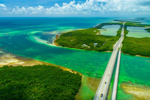
Driving the U.S. Route 1 across the Florida Keys sounds like pure paradise. The Seven Mile Bridge and open-water vistas are undeniably striking. But rising sea levels and stronger hurricanes have made the route more vulnerable and periodically damaged. Sections require constant maintenance to keep the roadway safe.
Tourism has also intensified, especially between Miami and Key West. During peak travel times, traffic backs up for miles with limited alternate routes available. Development along some stretches has replaced quieter waterfront views with commercial strips. It’s still unique, but less serene than its reputation suggests.
2. Route 66 (Illinois to California)

Once dubbed the “Mother Road,” U.S. Route 66 still carries a powerful nostalgia factor. But large stretches have been bypassed, rerouted, or left to crumble since it was officially decommissioned in 1985. In many places, what remains is a patchwork of frontage roads, cracked pavement, and fading signage. Instead of a continuous romantic drive, you often find yourself navigating disconnected segments.
Urban sprawl has also swallowed parts of the original alignment, especially near cities like Chicago and Los Angeles. Classic roadside motels and diners have closed or fallen into disrepair, replaced by chain businesses and interstates. While preservation groups work hard to maintain certain towns, other sections feel forgotten. It’s still historic, but it’s no longer the uninterrupted Americana dream many imagine.
3. Pacific Coast Highway (California)
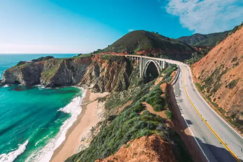
The California State Route 1 is still stunning in places, but it’s increasingly defined by congestion and closures. Landslides regularly shut down sections along Big Sur, sometimes for months at a time. Winter storms and coastal erosion have caused repeated damage, requiring major reconstruction efforts. What used to feel like a breezy coastal escape can quickly turn into a slow crawl.
Traffic near Los Angeles and the Bay Area often transforms the drive into a bumper-to-bumper experience. Popular viewpoints are crowded, and parking can be a challenge during peak seasons. Ongoing cliff instability means detours inland are common. The views are still there, but spontaneity has become harder to come by.
4. Blue Ridge Parkway (Virginia and North Carolina)
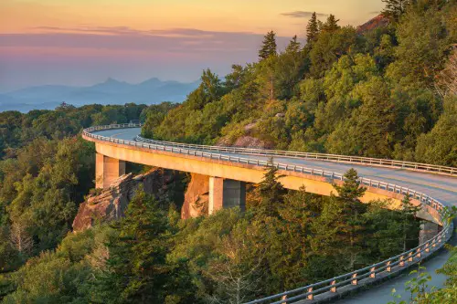
The Blue Ridge Parkway was designed for leisurely mountain driving. However, aging infrastructure has led to periodic closures for repairs and maintenance. Heavy rainfall events have triggered landslides in recent years, forcing temporary shutdowns. Deferred maintenance funding has also been a long-standing issue.
In peak fall foliage season, the parkway can become extremely crowded. Scenic overlooks often fill up by mid-morning, and traffic slows to a near stop. What was meant to be a tranquil nature drive can feel more like a procession. The beauty remains, but solitude is harder to find.
5. Going-to-the-Sun Road (Montana)
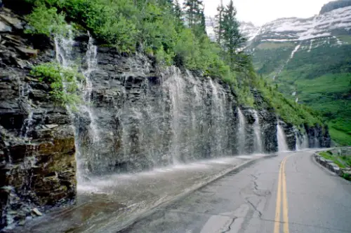
Going-to-the-Sun Road in Glacier National Park is famous for alpine views and dramatic engineering. Yet its short operating season limits access to just a few months each year. Snow removal can delay opening until late June or even July. Climate-related extremes have made maintenance more complex.
Vehicle restrictions and timed-entry reservations have also changed the experience. During summer, traffic congestion is common, and parking at Logan Pass fills quickly. Construction projects frequently rotate through different sections. The scenery is extraordinary, but planning and patience are now essential.
6. Hana Highway (Maui, Hawaii)
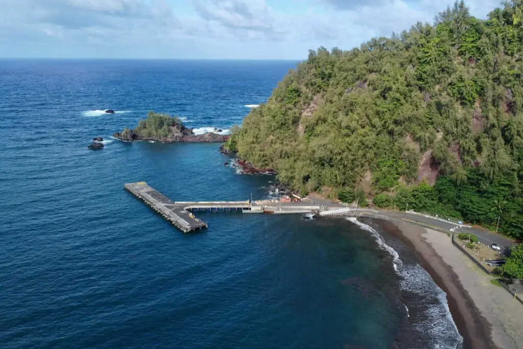
The Hana Highway is known for its waterfalls and lush rainforest. However, increased tourism has dramatically altered the drive’s atmosphere. Narrow one-lane bridges and tight curves create bottlenecks when traffic surges. Rental cars line the shoulders at popular stops.
Local communities along the route have expressed concerns about overcrowding and trespassing. Some areas now limit parking or restrict access to protect natural resources. Flash flooding and storm damage can also close parts of the road. It remains beautiful, but the sense of untouched discovery has faded.
7. Skyline Drive (Virginia)
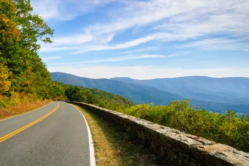
Skyline Drive runs the length of Shenandoah National Park with sweeping valley views. Yet haze from air pollution has historically reduced visibility, particularly in summer. While conditions have improved over the decades, certain days still lack the crystal-clear panoramas people expect. Seasonal wildfire smoke can also impact air quality.
Crowds peak during autumn foliage season, leading to packed overlooks and slow-moving traffic. Entrance lines at park gates can stretch for miles on busy weekends. Maintenance and weather-related closures occasionally disrupt travel. The road is scenic, but not always as pristine as the postcards suggest.
8. Beartooth Highway (Montana and Wyoming)
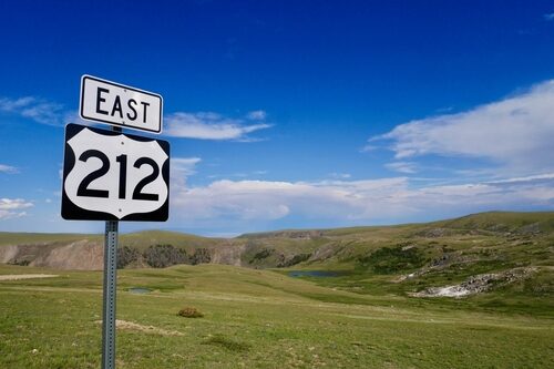
The U.S. Route 212 climbs to nearly 11,000 feet with dramatic switchbacks. Its high elevation makes it vulnerable to extreme weather and frequent closures. Snow can linger well into late spring, shortening the driving season. Sudden storms can create hazardous conditions even in summer.
Increased popularity has also brought heavier traffic during peak months. Construction to repair frost heaves and pavement damage is a regular occurrence. Limited services along the route can make delays more stressful. The rugged beauty is intact, but reliability is not guaranteed.
9. Historic Columbia River Highway (Oregon)
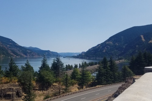
The Historic Columbia River Highway was America’s first scenic highway. Wildfires in the Columbia River Gorge, particularly in 2017, caused significant damage to surrounding forests. Some viewpoints were temporarily closed due to falling rock hazards and burned landscapes. Recovery has been ongoing for years.
While restoration efforts are impressive, sections still show signs of fire impact. Popular waterfall stops like Multnomah Falls often draw heavy crowds and require timed permits during peak periods. Parking limitations can frustrate spontaneous travelers. It’s a historic gem, but no longer the quiet forest drive it once was.
10. Natchez Trace Parkway (Mississippi to Tennessee)
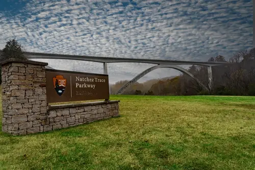
The Natchez Trace Parkway was once celebrated for its calm, uninterrupted drive. Commercial traffic is prohibited, preserving some of its charm. However, suburban growth near Nashville and Jackson has brought more congestion at access points. Nearby development can intrude on the feeling of remoteness.
Storm damage and fallen trees periodically close segments of the parkway. Deferred maintenance has required bridge and pavement repairs in recent years. Wildlife collisions remain a concern, particularly with deer. It’s still peaceful in stretches, but not uniformly secluded.
11. Lake Shore Drive (Chicago, Illinois)
Lake Shore Drive once offered an elegant urban scenic route along Lake Michigan. Today, it’s more often associated with rush-hour gridlock than leisurely cruising. High-rise development has changed the skyline views over time. Construction projects frequently narrow lanes and slow traffic.
Winter weather off Lake Michigan can make driving treacherous. Snow, ice, and strong winds regularly impact road conditions. What was once a breezy lakeside experience can feel tense and crowded. The lake is still there, but the serenity often isn’t.
This post Scenic Routes That Aren’t So Scenic Anymore was first published on American Charm.