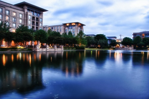
1. White Plains, New York
Just 30 miles north of Manhattan, White Plains was poised to be a model commuter suburb with a dense, walkable downtown. Its compact layout and train connection made it ideal for urban-style development. For a while, it thrived with department stores and mixed-use buildings close together. But postwar development brought a tidal wave of parking lots and garages.
White Plains Mall was surrounded by parking that isolated it from the rest of downtown. Even newer developments often include oversized parking decks, further breaking up the pedestrian experience. The bones of a walkable city are still there—but they’ve been covered in concrete. Ironically, people often drive from one part of White Plains to another, even if it’s only a few blocks.
2. Columbia, Maryland
Columbia was one of the most ambitious planned communities in the U.S., founded in the 1960s to prioritize people over cars. Its villages and town center were supposed to foster community through walkable layouts. Early on, it featured footpaths, bike lanes, and clustered housing near shared spaces. But over the decades, surface parking grew like weeds around its key hubs.
The Town Center, meant to be the vibrant, walkable core, is now surrounded by expansive parking serving the mall and office buildings. The original goal of reducing car dependency has faded under decades of suburban development pressures. Even small errands often require a drive instead of a stroll. Columbia’s ideals survive—but they’re buried under parking stripes.
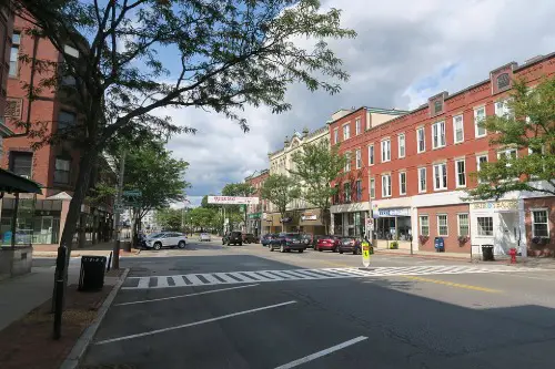
3. Plano, Texas
Plano had dreams of being more than just a Dallas suburb—it wanted to be livable and walkable, especially in its Legacy area. Legacy West was designed as a mixed-use development with residential, retail, and office space all within walking distance. But much of the surrounding area remains dominated by wide roads and enormous parking lots. This has created an awkward patchwork of walkability.
You can stroll through the carefully planned parts of Legacy, but stepping outside often means dodging traffic or crossing seas of parked cars. The city’s zoning laws still heavily favor car travel, with minimum parking requirements encouraging more lot development. Despite transit plans and bike lanes, the car reigns supreme. The vision is there—but it’s boxed in by asphalt.
4. Reston, Virginia
Reston was one of the first master-planned communities in the U.S., envisioned in the 1960s as a walkable utopia. Founder Robert E. Simon emphasized mixed-use neighborhoods where you could live, work, and play without needing a car. The village centers were meant to be compact and pedestrian-friendly, surrounded by trails and natural areas. But over time, surface parking lots multiplied around these centers, chipping away at their original design.
As Reston grew, development prioritized ease of access for vehicles over walkability. North Point Village Center and other areas ballooned with surface parking, often making it difficult to walk between nearby shops without dodging traffic. Ironically, Reston now struggles with car dependency—despite its ambitious, anti-car roots. The original pedestrian pathways still exist, but they’re often bypassed in favor of driving from one lot to another.
5. Bellevue, Washington

Bellevue aimed to be Seattle’s sophisticated, walkable counterpoint. Its downtown was developed with transit, density, and pedestrians in mind, especially as it became a tech hub. Early plans in the 1980s tried to blend urban-style blocks with green spaces and foot traffic. Yet as big office buildings sprouted, so did giant parking structures and lots around them.
Even with a growing skyline, Bellevue’s streets are dominated by wide roads and awkwardly placed lots. You’ll often find yourself crossing four lanes of traffic just to get from one shop to another. Parking lots sliced up what could have been a continuous, walkable downtown core. Today, Bellevue is trying to course-correct—but the car-first design lingers.
6. Walnut Creek, California
Nestled in the East Bay, Walnut Creek was once heralded as a suburban town with a real downtown experience. Its BART station gave it potential as a transit-oriented, walkable suburb. Developers even designed compact shopping areas like Broadway Plaza to support pedestrian life. But over time, massive parking garages and surface lots started filling in the spaces between destinations.
Broadway Plaza itself is now ringed by garages that interrupt the pedestrian flow. The charming idea of strolling from coffee shops to boutiques has turned into a game of parking lot hopscotch. Even streets adjacent to the downtown core are dominated by cars and traffic. The walkable promise is still there—but you need to navigate a lot of asphalt first.
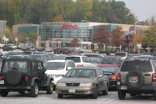
7. Schaumburg, Illinois

Home to Woodfield Mall—one of the largest in the country—Schaumburg tried to fuse walkability with suburban convenience. Planners imagined office parks and mixed-use areas connected by paths and greenways. But the mall’s success led to explosive commercial development and, with it, sprawling parking lots. The result: a landscape built for shopping, not strolling.
Even the town’s recent efforts at creating a walkable “urban core” have struggled against the tide of car-first planning. Wide boulevards and isolated buildings make walking feel more like a chore than a pleasure. Developers now face the challenge of retrofitting walkability into a space dominated by parking. Schaumburg’s ambition is real—but the asphalt keeps winning.
8. Tysons, Virginia

Tysons was famously known as “a city built for cars,” but not for lack of trying. Long before its current density, planners floated walkability as a goal—even dubbing it a “downtown” for Northern Virginia. Yet development leaned hard into highways, office parks, and shopping malls—each with massive surface parking. Metro access came later, but by then the damage was done.
Even today, walking between the four Metro stations can feel disjointed, thanks to wide roads and giant lots. New developments try to fix this with denser, mixed-use buildings, but they still sit adjacent to old parking-heavy blocks. Efforts like Tysons Corner Center’s plaza are helping—but the transition is painfully slow. The gap between vision and reality is measured in parking spaces.
9. Irvine, California

Irvine is the poster child of planned suburbia, and early designs promised a balanced lifestyle with walkable neighborhoods. The Irvine Company laid out village-style plans, parks, and trails connecting homes to shops and schools. But rigid zoning and an overreliance on car access turned many centers into parking-heavy islands. Even mixed-use districts are often set behind large parking lots.
The Spectrum Center is a great example—it’s lively inside but hemmed in by expansive lots and garages. Walking or biking between nearby districts is awkward and often unsafe due to wide arterial roads. The master plan intended for self-contained walkability—but not necessarily interconnectedness. In Irvine, every walkable area feels like its own little parking-surrounded bubble.
10. Sandy Springs, Georgia
A close-in Atlanta suburb, Sandy Springs wanted to evolve from sleepy residential streets into a more urbanized, walkable center. City Springs, the new downtown hub, was built with walkability and civic life in mind. But the surrounding development followed older patterns—single-use zoning, strip malls, and seas of parking. As a result, walking beyond a few blocks still feels uncomfortable.
City Springs itself is pleasant and compact, but nearby you’ll find intersections better suited for NASCAR than pedestrians. Planners continue to try stitching these parts together with trails and pedestrian improvements. Still, cars dominate the space between walkable islands. Sandy Springs is trying to walk—but it’s stuck in a lot.
11. Natick, Massachusetts
With a commuter rail station and a quaint downtown, Natick had all the ingredients for walkability. But the development of the massive Natick Mall and the surrounding area shifted focus toward car-centric retail. The mall itself is encircled by a huge parking lot, severing it from the rest of town. What could’ve been a connected extension of downtown became a traffic magnet instead.
Even though the old town center is charming and compact, getting from there to newer development almost requires a car. Sidewalks and crossings aren’t prioritized in the sprawling retail zone. Natick’s walkable identity is split in two: the cute downtown, and the asphalt ocean around the mall. Reunifying them will take more than just paint and planters.
12. Chandler, Arizona

Chandler had ambitions of building a dense, walkable downtown in the heart of sprawling Phoenix suburbia. And to some extent, it succeeded—its historic downtown area is compact and lively. But all around it, surface parking and wide roads slice through potential pedestrian connections. Even new developments are often fronted by large lots instead of street-level storefronts.
Downtown Chandler has become a kind of walkable island surrounded by car-oriented development. It’s not uncommon to drive to multiple places within a half-mile radius due to poor pedestrian infrastructure. This contradiction has made the city a case study in partial walkability—where the core is great but the surroundings undermine it. The dream persists, but it’s hemmed in by blacktop.
This post 12 American Suburbs That Were Supposed to Be Walkable—Until Parking Lots Took Over was first published on American Charm.