1. Cincinnati Subway (Cincinnati, Ohio)
Beneath the streets of Cincinnati lies an entire subway system that was never completed, but parts of it are still used—for utilities. Construction began in the 1920s with grand plans to ease city traffic and connect neighborhoods via a modern rapid transit system. Unfortunately, funding dried up before any trains could run, and the project was officially abandoned in the 1950s, according to Andrew J. Hawkins from The Verge. Still, the empty tunnels remain beneath the city, and today they house water mains, fiber-optic cables, and other critical infrastructure.
While it’s eerie to think of an entire subway system gathering dust underground, the tunnels have found a strange kind of second life. The city has used them for decades to run modern utilities safely and out of sight. There have been occasional efforts to revive the idea of a subway, but nothing has gotten traction. For now, Cincinnati’s ghost subway continues to serve the city in its own quiet way.
2. Interstate H-3 (Hawaii)
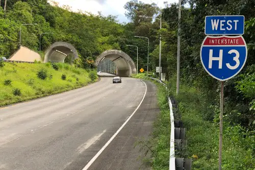
Interstate H-3 in Hawaii is a marvel of engineering—and controversy. Originally planned in the 1960s to connect Honolulu with Marine Corps Base Kaneohe, it was plagued by protests, environmental challenges, and budget blowouts. While most of the road was eventually completed, several access points and connector ramps were never finished. Yet it still operates daily, carrying drivers across the lush Koolau mountain range through breathtaking tunnels and bridges.
Despite being incomplete by original design, H-3 has become a vital route on the island of O’ahu, according to Kevin Allen from Hawaii Magazine. Some ramps and interchanges that were planned to ease traffic never materialized, leading to traffic flow quirks. Its scenic beauty and engineering complexity make it one of the most dramatic stretches of American highway, but it’s also a symbol of how large projects can stall. It’s fully functional—just not the way planners envisioned decades ago.
3. California State Route 39
State Route 39 in California was supposed to be a stunning, uninterrupted drive through the San Gabriel Mountains. But a massive landslide in 1978 wiped out a chunk of the road near Angeles Crest Highway—and it was never repaired. Decades later, the road remains technically “open” on both ends, but you can’t actually drive through, according to Erin Rode from SF GATE. It’s closed in the middle, with barriers and warning signs where the pavement just disappears.
Still, people continue to use the accessible portions of Route 39 for hiking, biking, and scenic drives. It’s especially popular with outdoor enthusiasts and motorcyclists. Caltrans has occasionally floated the idea of repairing the damaged section, but costs and environmental concerns have kept it in limbo. So Route 39 continues to serve, just not as the seamless mountain highway it was meant to be.
4. Roosevelt Island Tramway (New York City)
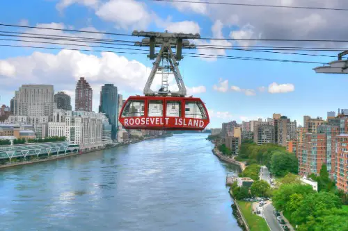
The Roosevelt Island Tramway wasn’t supposed to be a permanent part of New York City’s transportation system, according to Rossilynne Skena Culgan from Time Out. It was built in 1976 as a temporary solution while a subway connection to the island was under construction. But the tram proved so popular and useful that it stuck around, even after the subway line finally opened in 1989. The original system was eventually upgraded, but the route and idea remain essentially the same.
Today, it’s not just a quirky relic—it’s a fully integrated part of NYC transit. Commuters, tourists, and island residents still rely on it every day. What was meant to be a placeholder has become iconic, even making appearances in movies and postcards. It’s a rare case of temporary infrastructure becoming permanent through sheer usefulness and charm.
5. Bridge to Nowhere (San Gabriel Mountains, California)
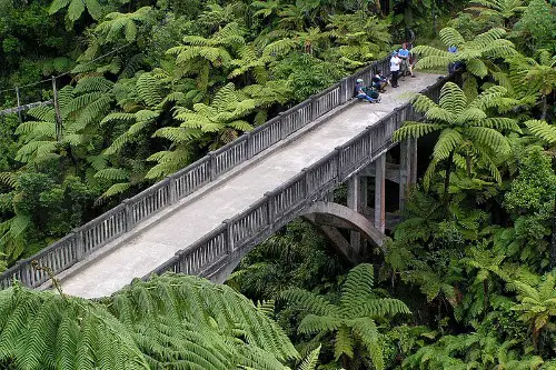
Deep in California’s San Gabriel Mountains stands the Bridge to Nowhere, a lonely concrete arch with no road leading to or from it. Built in the 1930s as part of a road project meant to connect the San Gabriel Valley to Wrightwood, the road was wiped out by a flood before it was finished. The bridge was never demolished and has stood isolated ever since. Despite its disconnected status, it’s far from forgotten, according to Aunindita Bhatia from The Travel.
Today, the bridge is the destination of a popular hiking trail that attracts thousands of visitors each year. It’s even used for bungee jumping tours, making it more active now than it ever was in its intended role. Nature reclaimed the road, but the bridge remains, a strange but beautiful example of infrastructure surviving without context. It’s a reminder of how plans can change—but some structures endure anyway.
6. Inner Belt (Boston, Massachusetts)
Boston’s Inner Belt was supposed to be a massive highway loop connecting the city’s outer areas, meant to ease congestion in the urban core. But community backlash in the 1960s and ’70s stopped it cold, especially after whole neighborhoods were razed in preparation. Though the full loop was never completed, several segments of it—including parts of I-93 and the McGrath Highway—are still in heavy use. They’re orphaned pieces of a much larger, abandoned plan.
What’s fascinating is that you can still spot clues of the Inner Belt’s ghost: strange road stubs, overbuilt interchanges, and “roads to nowhere.” Some urban planners even refer to it as the “highway that haunts Boston.” Despite its incomplete nature, the parts that were built have become integral to the city’s transportation network. It’s a case of abandoned plans becoming essential reality.
7. Washington Metro’s Silver Line Phase 2 (early segments)
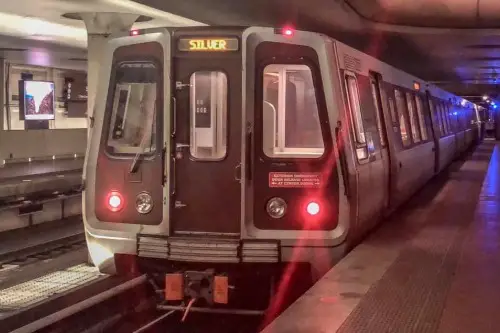
The Washington Metro’s Silver Line was envisioned to connect D.C. to Dulles International Airport and beyond, with construction beginning in the early 2000s. While most of the line is now finished, some early stations—like the one at Innovation Center—sat unused for years while the rest of the project caught up. Portions of track were built and maintained long before they were officially opened. And in some cases, these “inactive” pieces had to be kept functional for testing and maintenance.
Transit workers and engineers frequently used the unfinished segments for training or storage. Even while stations weren’t serving passengers, they were helping keep the rest of the system running. Now that the full Silver Line is operational, it’s hard to remember the years when parts of it were built but idle. But those early segments were quietly working behind the scenes the whole time.
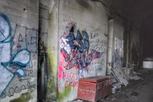
8. Pennsylvania Turnpike’s Abandoned Tunnels
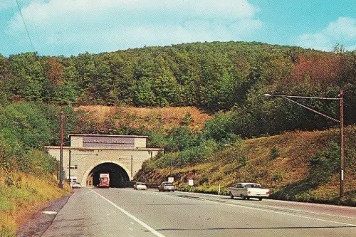
When the Pennsylvania Turnpike opened in 1940, it reused several old railroad tunnels to carve its way through the Appalachians. But by the 1960s, some of those tunnels became bottlenecks, leading the state to build bypasses and abandon the original tunnel sections. The Sideling Hill and Rays Hill tunnels were left behind, but they didn’t just vanish—they became part of a unique stretch called the “Abandoned Turnpike.”
Today, hikers and cyclists use this eerie, graffiti-covered stretch as a kind of unofficial recreational trail. It’s a popular destination for explorers and photographers, thanks to its post-apocalyptic vibe. Though it’s no longer part of the highway system, the road still serves the public in a very different way. It’s not what the engineers had in mind, but it’s definitely not forgotten.
9. Lake Pontchartrain Causeway (Louisiana)
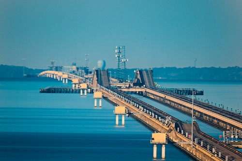
The Lake Pontchartrain Causeway in Louisiana stretches for nearly 24 miles, making it one of the longest bridges in the world. While the bridge is completed and functional, an ambitious network of interchanges and service roads along both ends was planned but never fully realized. Budget constraints and changing traffic demands meant that some ramps and connections were canceled mid-design. Yet, the bridge remains heavily used and essential to commuters.
There are still odd, unfinished stubs of roads and right-of-way clearings that hint at the larger system that was once intended. Drivers pass them without a second thought, but they’re remnants of a more complex vision that never materialized. The causeway itself functions perfectly well, but the ghost infrastructure at either end reminds us of what could’ve been. Sometimes, the main project finishes, even if the extras don’t.
10. Columbia River Highway (Oregon)
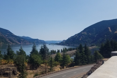
Built in the early 20th century, the Columbia River Highway was a masterpiece of scenic roadway design. It was intended to run continuously along the Columbia River Gorge, but sections were bypassed or abandoned during the construction of more modern highways like I-84. Many of the original road’s segments are now incomplete, cut off from one another. But they’re still used—as parks, trails, and even bike paths.
The highway’s abandoned tunnels and stonework bridges now serve as a kind of outdoor museum. Parts of it, like the Historic Columbia River Highway State Trail, are maintained for recreation and sightseeing. Though it no longer forms a complete route, its fragments are cherished and frequently visited. It’s a rare case where incomplete infrastructure has become beloved in a whole new way.
11. Alaskan Way Viaduct (Seattle, Washington)
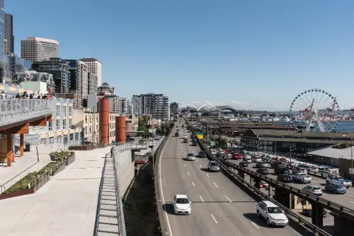
The Alaskan Way Viaduct was once a major highway running through downtown Seattle, but the structure was aging and vulnerable to earthquakes. The state planned to replace it with a tunnel, which finally opened in 2019—but not all of the transition infrastructure was completed as planned. Some ramps and connector roads were removed or left unfinished due to cost and community input. Still, parts of the old alignment and side roads are in use today, adapted for freight and surface traffic.
Several remaining stubs and roadways now serve as local access points, even though they were originally designed for highway throughput. Pedestrian paths and bike lanes have also taken over certain sections. The original grand vision was only partially fulfilled, but the bones of the project remain alive. Seattle managed to repurpose a shaky piece of history into something more grounded.
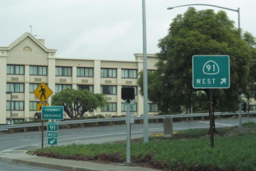
12. Foothill Freeway (California State Route 210)
California’s Foothill Freeway was supposed to be a major east-west corridor linking Los Angeles suburbs all the way to Redlands. While most of the route is complete, a few sections, especially interchanges and lane expansions near San Bernardino, were never fully built out. Drivers still use these areas every day, despite odd lane merges and awkward exits. It’s one of those cases where a project got almost done—but not quite.
Budget shortages and local opposition played a big role in leaving some ramps and connectors unfinished. And yet, the freeway still gets the job done, carrying thousands of vehicles daily through the Inland Empire. For longtime residents, those incomplete pieces are just part of the commute. But they’re also a testament to how big plans often get scaled back in real time.
13. Florida’s I-4 “Dead Zone” (Orlando Area)
Interstate 4 in Florida has long been infamous for its chaotic stretch through Orlando, often called the “I-4 Dead Zone.” When the highway was first constructed in the 1960s, several interchanges and service roads were never finished, partly due to wetlands, funding issues, and evolving traffic needs. Those unfinished elements remain today—overpasses that lead nowhere, ramps with barriers, and odd traffic patterns. Yet, the highway is still a major artery for Central Florida.
Efforts to revamp the I-4 corridor have been ongoing for decades, with mixed results. Drivers have learned to navigate the quirks, even as construction continues to tweak and improve the route. It’s a prime example of how infrastructure can be both indispensable and flawed. The I-4 “Dead Zone” may be incomplete, but it’s as heavily used as any finished highway in the country.